Geomatics
Geomatics, Surveying and Geographical Information Systems
Geographic Information Systems (GIS)
Geographic Information Systems (or GIS) are computer systems that capture, store, displace and generate geographical information as maps or data. This geographical information takes the form of vector data, raster data or geospatial databases.
GIS allows the archaeologist to digitise and create datasets, generating information that can be shared with other stakeholders as vector data, raster images and maps.
GIS can be used to access and query the large and freely- available heritage datasets from the Irish government, like the Sites and Monuments Record (SMR) and the National Inventory of Architectural Heritage (NIAH). GIS can also be employed with computer-aided design (CAD) technology to view and create vector data relevant to a project or development. It can also be utilised to analyse and model real-world environments for the purpose of identifying or predicting the presence of archaeology.
GIS allows the archaeologist to bring together and compare different geographical datasets, created for different purposes, easily and in a cost-effective way, with the intention of informing archaeological research questions and mitigation strategies.
AMS employs GIS extensively on projects to view CAD drawings of proposed developments; compare these with previously recorded archaeological sites and monuments records or historical maps; view the product of remote sensing surveys like geophysical surveys, Lidar or photogrammetry; and to generate maps showing these relationships. We also use maps to share information with clients and statutory authorities, and to illustrate strategy documents, reports and publications.
Meet the Team

Raúl Zafra
Raúl is a Senior Tech Engineer with seventeen years of experience working in Spain, the UK and Ireland on small and large-scale infrastructural projects. His special area of expertise is Geomatics, but he also has a focus on technology and innovation.
Raúl is familiar with GIS software and CAD tools. He is an advanced user of QGIS and Autocad/Autocad Map 3D. He is also an advanced user of Microsoft Office, Office 365 tools, and Adobe Illustrator, with experience in programming languages such as BVA and Python.

Dr Martin Duffy
Martin is a GIS and remote sensing specialist, with a particular interest in applying digital solutions to archaeological research.
He holds an Msc from NUI Maynooth in GIS and remote sensing and one from University College London in archaeological GIS and spatial statistics. In the past he has worked with remotely sensed satellite data, and has completed his PhD thesis entitled “Mapping social, ideological and economic transformations: settlement and landscape in the early medieval kingdom of Brega, AD 400-1100” which relies heavily on GIS to study settlement in the early medieval kingdom of Brega.

Kevin Costello
Kevin has worked as a commercial archaeologist on a number of projects in the last four years in Louth, Roscommon, Dublin, and in the UK.
Kevin has a particular interest in GIS (his undergraduate thesis focused on site catchment analyses which examined the proximity of open-air mass-sites to their local archaeological and natural environment). His other areas of archaeological interest are prehistoric and post-medieval rock art/engravings.

Richy Hinchy
Richy has over ten years’ experience working as an archaeologist in Ireland but traded in his trowel to take up the position of IT support technician in the Netherlands. He returned to Ireland a few years ago and now works as a surveyor and geomatics specialist.

Alistair Branagh
Alistair completed an undergraduate degree in Archaeology at the University of Glasgow in 2016, following this with a Masters in World Heritage Management and Conservation at UCD.
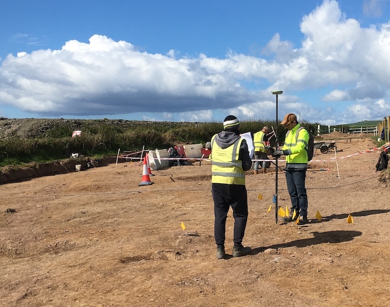
He has since worked in commercial archaeology across Scotland, England and Ireland on a variety of small to large-scale archaeological sites ranging from prehistoric through to post-medieval. During this time, he trained in GIS and Surveying. His geomatics experiences covers excavation and post-excavation processing, GNSS and Total Station surveying, mapping in QGIS and ArcGIS, and undertaking desktop assessments. He also provides training in surveying, processing geospatial data and mapping in QGIS.
Alistair’s particular interest is in the adoption of new technologies within the archaeology and heritage sector, notably the use of 3D modelling and reconstruction. The focus of his academic research involved the use and viability of 3D reconstructions to supplement or replace the visitor experience on heritage sites. This is particularly applicable to sites which are inaccessible or where the archaeology is endangered by overtourism.


